

West Pomeranian University of Technology in Szczecin
Aerobits cooperated with the West Pomeranian University of Technology in Szczecin (ZUT) on a GS3L receiver installation for testing cooperative drone monitoring in an urban environment. The station combines ground reception, data delivery over MQTT and visualization in PlaneMap V2. Observations include drone reception during the Żagle 2026 event in Szczecin and separate long-range reception of high-altitude aircraft.
Project Snapshot
| Field | Value |
|---|---|
| Partner | West Pomeranian University of Technology in Szczecin (ZUT) |
| Industry | Higher Education & Research |
| Country | Poland |
| Application | Urban Remote ID Testing and Cooperative Airspace Monitoring |
| Aerobits Solution | GS3L with integrated Remote ID electronics + PlaneMap V2 |
| Technology | Remote ID, ADS-B and FLARM; MQTT/JSON data delivery |
Partner Overview
The West Pomeranian University of Technology in Szczecin is a public university established in 2009 through the merger of the Szczecin University of Technology and the Agricultural University in Szczecin. Its education and research activities span engineering, computer science, life sciences and economics, connecting interdisciplinary research with practical applications. About ZUT
The cooperation focuses on testing a Remote ID receiver station in an urban environment to evaluate its practical application in cooperative drone identification and monitoring.
The Challenge
The project addresses the practical challenge of receiving drone identification and position data in a city and presenting it for inspection and analysis. Testing the receiver station in Szczecin provides a basis for assessing reception distances and viewing drone activity in its geographic context.
The project addresses the need to:
- Identify and track cooperative drones
- Evaluate Remote ID reception in an urban environment
- Make collected information available for visualization and analysis
- Make receiver data accessible through MQTT and JSON
- Build practical experience for future cooperative airspace monitoring applications
Why Aerobits?
The project combines Aerobits receiver hardware with its PlaneMap V2 visualization application. GS3L collects cooperative surveillance data, while the application provides a map-based view of received objects and their associated information.
Data delivery through MQTT in JSON format makes station output accessible for software integration and analysis, linking reception hardware with the tools used to inspect the collected data.
The Solution
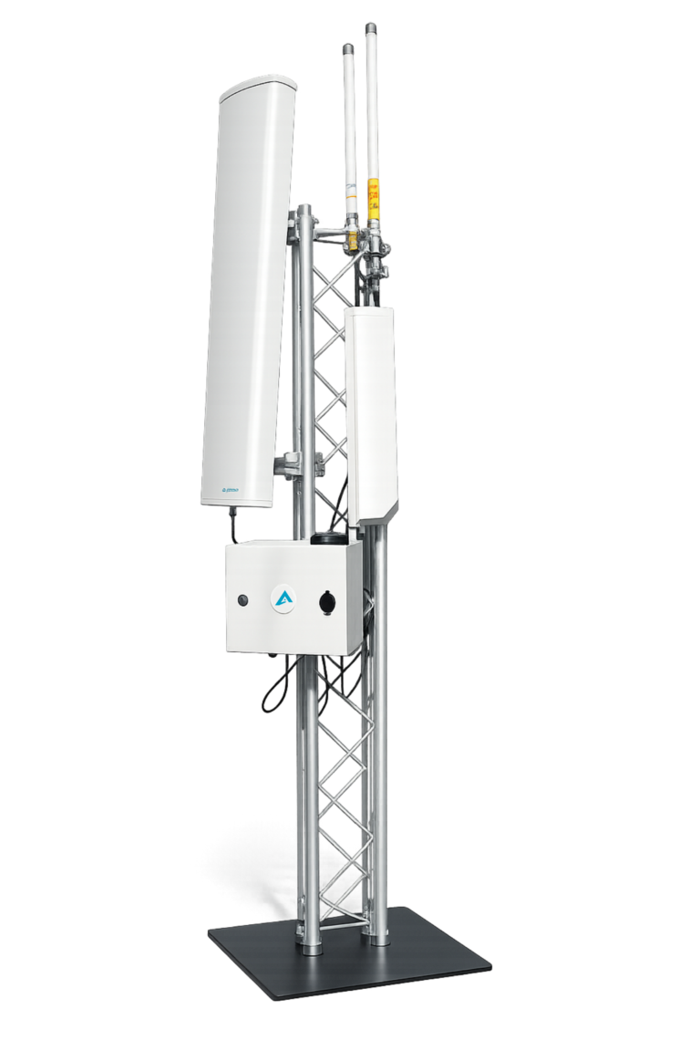
The ZUT installation is based on a GS3L ground receiver station and antenna setup. Remote ID electronics based on the idME design are integrated into GS3L on an mPCI board, rather than supplied as a separate enclosed idME device.
GS3L provides the ground reception layer. Its configurable architecture supports ADS-B, FLARM, and Remote ID, allowing the receiver configuration and antenna arrangement to be adapted to the monitoring requirements. View GS3L product
GS3L sends data through MQTT using JSON, a structured format suitable for processing by software applications.
Aerobits PlaneMap V2 is used to visualize the received data. The test-drone view includes position, altitude, horizontal and vertical velocity, identification fields and radio reception parameters. Operator markers are displayed alongside drone positions where the corresponding data is available.
The test-drone screenshot illustrates the information available for an individual object, including a self-identification field, received signal strength and radio-technology statistics.
Reception Observations
During the Żagle 2026 event in Szczecin, the station received Remote ID data from drones and their operators. The project team reported a maximum recorded reception distance of 5.28 km during the event. The maps compile all drone and operator positions received over the entire event weekend across the city and waterfront; they do not show simultaneous activity.
Separately, the station received high-altitude aircraft at distances of approximately 400 km, extending as far as Czechia, according to the project team. The team notes that reception at these distances is largely limited by Earth's curvature. The aircraft map shows over 40 aircraft received by the station at a single moment in time. This aircraft reception result is separate from the Remote ID drone observations.
Test and Reception Images


Customer Benefits
Technology Used
GS3L
Next-Generation Multi-Channel Airspace Monitoring Station
The ground infrastructure used in the ZUT deployment for multi-protocol cooperative airspace monitoring. GS3L provides a configurable receiver platform supporting ADS-B, FLARM and Remote ID, with data delivery for integration and analysis.
Used together with PlaneMap V2: Aerobits software visualizes received drone and aircraft positions, identification fields and radio reception data on a map.
Innovation Highlights
- Remote ID electronics integrated within the GS3L station
- Urban drone observations during Żagle 2026
- Configurable reception architecture
- MQTT data delivery in JSON format
- Map-based visualization and object details in PlaneMap V2
Ready to Build a Similar Solution?
Contact the Aerobits team to discuss your Remote ID reception, ground infrastructure and cooperative airspace monitoring requirements.
Contact Aerobits